Sunrise at Sleeping Bear Dunes revealed a cloudy sky after a quiet night in the campground.
Our plan for the day was to follow the shoreline and see what we could between here and Charlevoix.
An old lake fishing boat is docked on the opposite shore with the bow facing into the current.
A more modern fishing vessel was docked in front of a working fish house on our side of the river.
A dam limits boats from heading any further upstream than the Fishtown docks.
Closer to Lake Michigan, the sixty-five foot Mishe-Makwa was loading hikers and supplies for a trip to Manitou Island.
The newer parts of Leland had flowers everywhere, even placing planters along the bridge.
Shops in town continued the Fishtown motif. I looked for something monogramed with Leland, because it it my father's middle name, but only found a wool hat which just wouldn't be useful for him in Florida.
A large parking lot at the marina and boat launch allowed free parking between boats and a railroad themed restaurant. We may have to return to Leland.
Driving north to the tip of the Leelanau Peninsula we reached the 1858 Grand Traverse Lighthouse.
Like other Michigan lights, a fog horn building was constructed in 1899. Signs informed us that it took 55 minutes to get the boilers up to pressure to sound the two ten-inch fog horns.
Winds were over twenty knots and the lake was grey and high. Beth looked for Petoskey Stones without any luck.
Though most lighthouses charged to climb the tower, this was the first that charged admission to the keeper's quarters.
Library cases like this one stocked with books were sent to lighthouse keepers for education and entertainment.
Beth isn't fond of heights, so this photo of her in the tower is a big deal. It is the first time I recall her making it to the top of a lighthouse.
The view was worthwhile and the windy, cloudy day made it pleasant to be in a glass enclosed tower.
Panoramic view from the top.
Someone took the time to make an impressive model of the lighthouse from Lego bricks.
We parked near this expansive cedar tree. The long branches don't seem to have enough support, but somehow they hold themselves above the ground.
For lunch we drove next door to the Leelanau State Park campground. Sites, like this one, have wonderful views of Lake Huron. Because it wasn't crowded we made sandwiches and watched the water while we ate.
On the way out of the State Park, Beth noticed swans floating behind a sand bar for protection from the wave action on the big lake.
Driving back down the peninsula, we stopped at the Woolsey Memorial Airport. If Hobbits built an terminal, this might be it.
With no people and no airplanes around, I looked up the location on while standing in the "tower."
From Leelanau.com:
The Woolsey Memorial Airport is a public airport located three miles Northeast of Northport. The runway is turf, and there is no control tower. The airport is closed from November to March when the runway is covered with snow.
Every year they host the Woolsey Airport Fly-in and Pancake Breakfast which features some great planes from every era … and pancakes.
Lat/Long: 45-09-53.9970N / 085-34-18.3040W
Elevation: 628 ft. / 191.4 m (surveyed)
Elevation: 628 ft. / 191.4 m (surveyed)
Nestled between Elk Lake and Grand Traverse Bay, Elk Rapids was our next stop.
Pretty gardens mark the entrance to a pedestrian bridge linking the main street to the island housing the town library.
The town beach was deserted on a blustery day.
Shops with painted brick facades line main street in Elk Rapids.
The most unique building was this toy shop. It looks like it might have been designed by the same people that did Woolsey Airport.
The only elk we found in Elk Rapids was this iron sculpture.
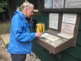
Fisherman's Island State Park was our campground. We picked our site and paid via check deposited in a pipe like in State Forest Campgrounds. The only twist was using the yellow phone to check that the site we chose hadn't been reserved by someone else.
Lake Michigan peeks through the trees between the fire pit and picnic table in our site.
Looking back at our silver van from the beach.
A lone gull shared the beach with us as we explored the beach on Lake Huron.
A large mining operation lies just outside and northeast of the park. We chose to look west and south.
Panoramic view of "our" campsite and beach.
Walking down to the beach we were rewarded when a gap in the clouds allowed a glimpse of the sunset as a fine bookend for the day.


No comments:
Post a Comment
We appreciate your comments! They will be published as soon as we get a chance to read them. Solicitations will not be published.